Demographic – Bücher, CDs, LPs und mehr, Seite 5
Wir konnten keine exakten Treffer zu Ihrer Suche nach "demographic" finden. Könnten diese Produkte zu Ihrer Suche passen?
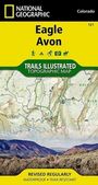
National Geographic Maps - Trails Illustrated
Eagle, Avon Map
lieferbar innerhalb 2-3 Wochen
Karten
Aktueller Preis: EUR 14,46

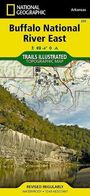
National Geographic Maps - Trails Illustrated
Buffalo National River East Map
lieferbar innerhalb 2-3 Wochen
Karten
Aktueller Preis: EUR 14,46

National Geographic Maps - Trails Illustrated
Crested Butte, Pearl Pass Map
lieferbar innerhalb 2-3 Wochen
Karten
Aktueller Preis: EUR 14,46

Daniel Marbot
Gastronomy In Transition
lieferbar innerhalb 2-3 Wochen
Buch
Aktueller Preis: EUR 19,00
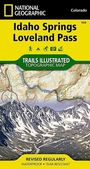
National Geographic Maps - Trails Illustrated
Idaho Springs, Loveland Pass Map
lieferbar innerhalb 2-3 Wochen
Karten
Aktueller Preis: EUR 14,46
![National Geographic Maps - Adventure: Yucatan Peninsula: Riviera Maya Map [Mexico], KRT](https://lesen.de/image/w90/front/0/9781566952453.jpg)
National Geographic Maps - Adventure
Yucatan Peninsula: Riviera Maya Map [Mexico]
lieferbar innerhalb 1-2 Wochen
Karten
Aktueller Preis: EUR 14,46
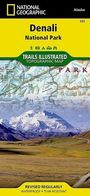
National Geographic Maps - Trails Illustrated
Denali National Park and Preserve Map
lieferbar innerhalb 1-2 Wochen
Karten
Aktueller Preis: EUR 14,46
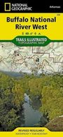
National Geographic Maps - Trails Illustrated
Buffalo National River West Map
lieferbar innerhalb 2-3 Wochen
Karten
Aktueller Preis: EUR 14,46

National Geographic Kids
125 True Stories of Amazing Animals
lieferbar ab 18.6.2026.
Buch
Aktueller Preis: EUR 13,28
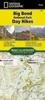
National Geographic Maps - Trails Illustrated
Big Bend National Park Day Hikes Map
sofort lieferbar
Karten
Aktueller Preis: EUR 14,46
![National Geographic Maps - Trails Illustrated: Uncompahgre Plateau South Map [Uncompahgre National Forest], KRT](https://lesen.de/image/w90/front/0/9781566955843.jpg)
National Geographic Maps - Trails Illustrated
Uncompahgre Plateau South Map [Uncompahgre National Forest]
lieferbar innerhalb 2-3 Wochen
Karten
Aktueller Preis: EUR 14,46
![National Geographic Maps: French Broad and Nolichucky Rivers Map [Cherokee and Pisgah National Forests], KRT](https://lesen.de/image/w90/front/0/9781566953870.jpg)
National Geographic Maps
French Broad and Nolichucky Rivers Map [Cherokee and Pisgah National Forests]
lieferbar innerhalb 2-3 Wochen
Karten
Aktueller Preis: EUR 14,46
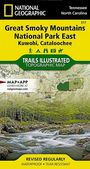
National Geographic Maps - Trails Illustrated
Great Smoky Mountains National Park East: Kuwohi, Cataloochee Map
lieferbar innerhalb 2-3 Wochen
Karten
Aktueller Preis: EUR 11,95

National Geographic Kids
How to Draw Safari Animals
lieferbar in mind. 4 Wochen
Buch
Aktueller Preis: EUR 8,51

National Geographic Kids
How to Draw Cute Animals
lieferbar in mind. 4 Wochen
Buch
Aktueller Preis: EUR 8,51

National Geographic Kids
How to Draw Ocean Animals
lieferbar in mind. 4 Wochen
Buch
Aktueller Preis: EUR 8,51
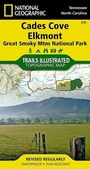
National Geographic Maps - Trails Illustrated
Great Smoky Mountains National Park West: Cades Cove, Elkmont Map
sofort lieferbar
Karten
Aktueller Preis: EUR 11,95
![National Geographic Maps - Trails Illustrated: White Mountain National Forest West Map [Franconia Notch, Lincoln], KRT](https://lesen.de/image/w90/front/0/9781566954655.jpg)
National Geographic Maps - Trails Illustrated
White Mountain National Forest West Map [Franconia Notch, Lincoln]
lieferbar innerhalb 2-3 Wochen
Karten
Aktueller Preis: EUR 14,46
![National Geographic Maps - Trails Illustrated: White Mountain National Forest East Map [Presidential Range, Gorham], KRT](https://lesen.de/image/w90/front/0/9781566954181.jpg)
National Geographic Maps - Trails Illustrated
White Mountain National Forest East Map [Presidential Range, Gorham]
lieferbar innerhalb 2-3 Wochen
Karten
Aktueller Preis: EUR 14,46
Informationen zur Lieferbarkeit bzw. zu Veröffentlichungsterminen von Artikeln beruhen auf Vorabinformationen unserer Lieferanten. Diese Termine sind ohne Gewähr und können sich jederzeit ändern.